In land navigation it’s important to crawl before you can walk, and determining your pace count is fundamental.
Every bit of information that you can gather about your location has it’s place in navigation, so no techniques should be discounted or ignored.
While some might dismiss pace count as a “waste of time” or “too hard to keep up with,” those are probably the same people who have never really had to find their way before.
A pace count will enable you to know the distance you’re traveling by determining, in advance, the number of paces it takes you to travel a pre-set distance.
You’ll then need to give yourself some kind of reminder that you’ve covered that distance, as well as each time you hit your magic number, or pace count.
Setup
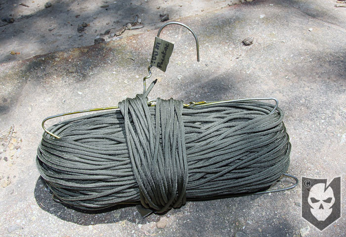
First, start with a 100 Meter measurement on flat terrain. We’ve got a 100m + length of 550 cord we use as a pace line. It’s wrapped around and spool that was created out of a coat hanger… Inventive right? Yep.
When we say 100 +, it means that on each end there is around 3 feet of extra 550 cord so it can be tied off to whatever is available in the terrain we’re in.
There’s also a tape marker indicating where the extra 550 cord starts on each end so that we can be as accurate as possible with our pace count.
With 100m of 550 cord, the line is going to sag no matter how tight you think you’ve pulled it. An option is to tie the line at a height even with where your hand hangs down at your side.
This will enable you to form an open loop with your thumb and index finger around the rope, and follow the line while walking. Just be sure that having your fingers around the line isn’t slowing your pace. You can also leave the line lying on the ground, but this will keep you looking down.
Walk the line
There’s not much left to do but walk the line. Start with your feet together on the starting line and step off with your left foot. Every time your left foot touches the ground, including your first step, count it.
Some people count every step, left and right, but we feel it’s better to have a smaller number to count to and count double paces. This will help you not to loose track as easily.
After walking your pace line, take out a notebook and pencil and write down your magic number. Walk the pace line at least two more times, add all the numbers together and divide by three. This is your base pace-count, and also the lowest it will ever be!
A high school track can also be utilized as a pace line if you don’t have the resources to create your own. The downfall to this will be covered further in the article.
Factors affecting pace count
After you’ve determined your pace count on a flat terrain, it’s time to get inventive. There are so many factors that can affect pace count that you may encounter.
Nightfall, weather (rain, snow, etc..), walking uphill, walking downhill, carrying a pack, terrain type (muddy, soft, etc…), mental and physical exhaustion.
These are all factors that will affect pace count, but believe it or not, all of these will never be lower than your base pace-count. Even walking downhill you’ll most likely take more steps than usual.
Keep in mind that distance on a map is “as the crow flies” and will not be an accurate representation of distance. For instance walking uphill will increase your distance and cause you to take shorter steps.
Based on the above information, we recommend war-gaming every scenario you can replicate and logging your pace count. Keep a record of how many paces it takes you to travel the 100m in each condition.
This is why a simple high school track won’t be sufficient, you need to get out into the types of terrain you could potentially encounter.
A pace-count log makes an excellent item to have laminated, and keep with you as a reference while navigating.
Update: See our new article on How To Make Your Own Pace Count Beads for Land Navigation
Are you getting more than 14¢ of value per day from ITS Tactical?
Please consider joining our Crew Leader Membership and our growing community of supporters.
At ITS Tactical we’re working hard every day to provide different methods, ideas and knowledge that could one day save your life. Instead of simply asking for your support with donations, we’ve developed a membership to allow our readers to support what we do and allow us to give you back something in return.
For less than 14¢ a day you can help contribute directly to our content, and join our growing community of supporters who have directly influenced what we’ve been able to accomplish and where we’re headed.


{ 9 comments… read them below or add oneDiscuss in our Forum }
Emphasis on the “write it down” part, haha. What was it again? 60? or was it 65? Was that open terrain or through brush? Hmmm….
LOL I know exactly what you mean. Gotta keep that log going! ~ Bryan
Pacing can be a pain in the arse over extended periods. As an army cadet, i don’t (normally)have access to a fancy gps to tell me how far i’ve gone. When you have to pace an 8km nav leg, it kan get a bit annoying (considering that 8km works out as about 10 000 paces in bushland!).
Pacing is a challenging skill on many levels.
First, tactically, it is difficult to keep a pace count and still focus on your surroundings. If your in a team / squad one person can be designated the paceman. But in a tactical environment it is your movement, body position, steps etc… that make a difference, you can just stand up and walk a line. Complicate that if you’er in a small team (such as a Scout Sniper or Forward Observer) and spend much of your crawling or stalking…
I generally rely on Terrain association (which has many challenges in and of itself (triple canoupe or alpine when you can’t see the terrain around you past a very feet). In a desert environment a solid pace count is a MUST (I still have a map that is solid tan with zero features and 2 total countour lines on it… you have nothing, nothing to do a resection etc… all you have is your pace). But in any terrain with contour and/or steady features, association is VERY accurate (usually more so than a GPS). But you have to be very famuliar with how a map “looks” and how that looks on the real ground.
Finally, by far biggest mistake in getting a pace count. Up/Down hill… as you said, “as the crow flys” distance on a map and actual distince on an incline are different. SO… simple taking a 100 meter cord and laying it out up a hill and getting a count (such as flat ground count = 60, uphill = 110…) simply doesn’t work. Example, you walk strait for 100 meters (60 paces) on flat ground and travel 100 meters on a map. Now you come to a cliff-face (90 degrees strait up for 100 meters) and pretending you can walk strait up (assualt climber up!!!) you use your “uphill pace” of 110 and travel 100 meters up, BUT… you have now traceled ZERO meters on the map, you haven’t moved at all. A regualur hill/mountain has this same propblem to the degree of it’s slope incline/decline. What I see many do is get a “uphill pace”, measure the distance on the map (say 300 meters) and assume they have to travel their “uphill pace” x3 to get to their end point… simple not true (I have seen it taught this way many times to include NASAR (National Organization of Search and Rescue) and many others…
This IS a way to calcualte a pace across incline and decline but it involves determineing actual distance (not strait line distance) by plotting on a seperate peice of paper each contour line that crosses your bearing then converting that into a line graph that creates a side view (as opposed to the down view of a map) of your terrain, then measuring the curved line to get an actual distance traveled (this is also a meathod we use to determine “dead space” of vision from a particular point overlooking an area (both for defense purposes and to know how to walk up a anothers position unseen). It is a time consuming meathod, can be complicated over long travel (such as a week long Patrol traveling 8-12 or more hours a day… slow moving I assure you). better to terrain associate if you are able. Good news is, in mountainous terrain, it is generally easier to terrain associate… but much of that depends on the age and accuracy of your map (but that is another subject). Good luck and be safe!
TacZen,
You’re right about the terrain association, on my latest cadet camp during our 48 hour exercise, my section didnt bother pacing during the day, we just relied on terrain. Now at night, that’s a different story…
Cdt Gillies:
Absolutely, every terrain and time has to be addressed differently. Terrain Associate here, Pace count there etc… In combat, it isn’t enough to know where you started and where you are at the end, you have to know EXACTLY where you are EVERY second. Cause if you make contact, you better be able to call for fire which is going to require first knowing you exact location and figuring it out while getting shot at. Figuring out a grid location using your Azimith and where you are currently in your pace count can be a challenge in the middle of a firefight, just hope you can see somehting VERY promimate that is also on your map and addjust from that…
Oh, and thanks, it has been 15-20 years, but I’ve done Patrols in your Country and it was wonderful (though quite Tick invested). Get times and you guys treated us wonderefully. If I can ever return the favor, let me know. Be safe.
My question CDT Gillies is why would you even try to pace count 8K’s, set up left and right boundaries and then a backstop behind your destination point, then use terrain association to get within 500m and then use a pace count. Trying to pace count 8K is pointless and leaves lots of room for error. This is just a suggestion
A nice trick is to have a short piece of paracord with a bunch of cord locks on your backpack/LCE. Move all of them up first. Then, every time you have pace counted 100m you move one of them down and start counting from 0. In the end just count the cord locks.
I have been reading the Navigation 101 articles posted by Bryan on ITS Tactical and I find them to be a great asset for someone learning just now, how to navigate, or someone that is remembering how to. Here is a question for the experienced:
If you were given a map and a compass and you found yourself in thick forestry in which the canopy extends for 75-100 ft of the ground, and you don’t have any line of sight towards usual landmarks (roads, shorelines, mountain peaks, valleys, depressions, etc) how would you locate your position on the given map? If you failed to penetrate the canopy to look beyond (e.g. you are injured and unable to climb) would that mean that you are lost? Or is there another way of getting bearings? If it involves relocating to a place where you ARE able to see landmarks, I don’t want to know :-). There are plenty of areas like what I am describing in the Northern US and Canada. And knowing where there is higher ground could save your life. The question is, how do you get to it?
In any case, thanks for posting these articles Bryan! I think its excellent knowledge!