Every Day Carry Planning – Step One: Security Threat Assessment

2 of 5 in the series EDC Planning

This is the second in a five part Every Day Carry series to help show how careful and reasonable planning will promote better selection of tools, resources and supplies for EDC kits. The first article in this series presented an overview of the analytical process for deciding on the composition of our kits. In a nutshell, the process involves the following four steps:

  1. Security Threat Assessment
  2. Articulate Reasonable Threat Responses
  3. Identify Necessary Tools, Resources and Supplies
  4. Allocate Items Among EDC kits kept at Home, Work, in your Vehicle(s) and on your Person

This article addresses the first step in the process, conducting a security threat assessment to identify the scope of events we’d like to be better prepared for with our every day carry kits.

Since this is a structured thought process, we need to look at it one piece at a time for better understanding and to see how one portion of the analysis relates to others. If done correctly, we’ll have a complement of items that are essential for our EDC kits. In addition, the same process conducted in reverse will allow us to validate the content of kits we’ve already assembled. Continue reading

Posted in EDC | Tagged , , , , | 7 Comments

LandNav 101: Reading and Associating Terrain

3 of 6 in the series LandNav 101

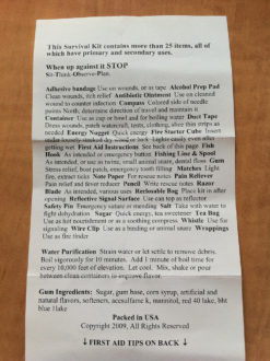
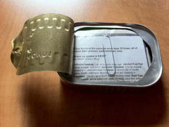
Today we’re going to discuss how to read terrain off of a map. Reading terrain is more about artistic visualization than it is science. There are three major factors that aid in the visualization of terrain from a 2d map:

  • Contour Lines
  • Colors
  • Shading

The ability to fuse these major factors is the most critical skill one can learn when using a topographic map. The primary purpose of a topographic map is to accurately represent the shape of the Earth’s surface, but the utility doesn’t stop there. Topographic maps also represent streets and trails, vegetation, streams, and every type of feature that may positively or negatively impact your ability to navigate through the terrain.

Contour Lines

Contour lines are imaginary; they are map artifacts used to represent paths or segments of Earth at an equal elevation. These paths and segments are presented as elevations (vertical distance above or below sea level) and reliefs (the shape of terrain features on the Earth’s surface).

Not all contour lines are created equal. Heavier contour lines are known as indexed contour lines and are normally numbered showing elevation. Typically every fifth contour line is an index.

Lighter contour lines, that fall between indexed lines, are known as intermediate contour lines. These lines do not have their elevation given and are found in sets of four between indexed contour lines. Finally, when the terrain is expansively flat, cartographers will often include supplementary contour lines, which are dashed lines indicating an elevation that is half of the elevation between the contour lines surrounding it. They are typically found where there is little change in elevation.

The key thing to remember about contour lines is this: The closer the spacing, the more rapid the change in elevation. For a leisurely Sunday stroll, you might be looking to cross just a few contour lines, or perhaps follow a trail that shadows a few contour lines on the map. For rock climbing, look for a concentration of contour lines in a single area. If you’re looking for a true vertical cliff, look for a series of contour lines drawn so closely together that they appear to be a single line.

The Huntsville quad doesn’t really have any hard elevation terrain (though navigating swamps can be pretty hard). Notice the foot trail along the top image. It intersects two indexed contour lines, but the distance between the indexed contours is pretty significant; it’s easy to see that this is a very easy path to navigate with respect to elevation gain.

In contrast, the bottom graphic shows a hill where the top is at 438′. The indexed contour line to the immediate left if 400′, and the one further left is 350′. Walking up the western face of this hill would be more challenging than traversing the easy foot trail.

Topographic Map Colors

As you can imagine, there’s an entirely different survival mindset for each environment. For example, surviving in the mountains above 10,000 feet in October is radically different than surviving in the desert in July. This is why it’s important to know the terrain you’re traveling into and what the map of that area is telling you.

The color brown is used to denote most contour lines on a map, which are relief features and elevations. Topographic maps use green to denote vegetation such as woods, while blue is used to denote water features like lakes, swamps, rivers and drainage.

At higher elevations, mountains may be snow-capped year around, or the terrain may actually be a glacier. In each of these cases, contour lines are also drawn in blue. It is therefore possible to quickly discern that a particular route from A to B might be more treacherous than operating at a high altitude–the trek might require crampons, an ice axe, and other materials that might not be readily available once in the backcountry.

Finally, black is used to represent man-made objects, including trails. Red is used for man-made features, like main roads or political boundaries, and purple for new changes or updates on the map that weren’t previously represented. Newer maps no longer use purple, but since so many older maps exist, it’s worth mentioning.

At the bottom of the Huntsville quad is Lake Raven shaded in blue, since it’s a water feature. Notice the thick red line, delineating a political feature, the state park boundary. The majority of the image is shaded green, showing that this part of the map is full of vegetation. Contour lines are present in brown, as are two different types of paths: an unimproved or 4 wheel drive trail represented by parallel dashed lines and a foot trail represented with a single dashed line.

Admittedly outside of our topographic scope, it’s worth noting that the USGS also provides extensive documentation on colors (and shading) for representing geologic features. This could be particularly useful for those interested in either rock climbing or geology in general. See the USGS Colors and Patterns for Geologic Maps for more details. If I ever get the opportunity to spend a couple weeks in southern Utah, I intend on bringing along a geologic map in addition to my topographic map because I enjoy knowing that I’m looking at rock that dates back to the Jurassic or Cretaceous period.

Shading

Color similarity between features does not mean that the features are equivalent. Due north of Lake Raven is the Prairie Branch, another name for a stream. Other names that equate to a stream include kill, run, fork, and brook. What’s interesting about Prairie Branch is that has led to the formation of a wooded marsh or swamp.

Navigating across Prairie Branch could be difficult. Since this is Texas, expect to run into water moccasins, copperheads and perhaps the occasional alligator among all of the other friendly animals that call Sam Houston National Forest home.

Remembering map colors is a fairly trivial task, but remembering the shadings is far more difficult given the sheer number of variations. For this reason, keeping the USGS Topographic Map Symbols, a mere two sheets of paper, behind your map can be a lifesaver. A quick reference to page four of the booklet confirms that Prairie Branch is indeed a submerged wooded marsh or swamp.

Terrain Association

Orienting the map is an exercise that rotates the map so that north on the map is aligned with north in the real world. Orienting a map is critical because it allows you to point in a direction and know with confidence what terrain lies ahead. But if your compass breaks, how will you know where you’re headed?

It happens! You may find yourself in the backcountry with a map, but that fall (more like a slide) down that last rock face shattered your compass. Now what? Well, the key is to read the terrain and orient your map, a skill called terrain association. This task is far easier in mountainous or hilly areas than in areas where there is little to no reference, like in the plains or in a rain forest where your view is blocked.

The Huntsville quad isn’t the Rocky Mountains, so orienting a map is more challenging because you can’t simply look around and pick out the tallest peaks. That doesn’t mean that orienting the map isn’t possible. Notice how the map helps you visually see a valley? Close your eyes and imagine standing in the flat valley, somewhere near the ‘n’ in Robinson, then look east.

The map tells us that the valley isn’t heavily vegetated because it isn’t in green, but the hills to the east are. We also can tell from the contour lines that there is a significant elevation change of about 100′. It then becomes possible to visualize a slinking, rapidly rising set of hills with at least four distinct faces. (I’ve annotated the map with ‘you’ to show your position, and four red arrows to show the faces to visualize). Valleys are often easy to identify because there is typically a water feature running through the middle; the water feature is typically responsible for carving out the valley.

In this image we can see two hills sitting across from each other. The change in elevation isn’t as dramatic as one might find in Utah or Colorado, but it’s a saddle. The key to identifying a saddle is to look for concentric circles with a space between them. Someone once told me that a saddle can be thought of as a frying pan with two eggs on it. There’s the surface of the pan, then there’s an elevation gain up to the egg whites and then there’s the top of the two hills, the yolks. It’s a silly but effective way to understand that the saddle is the dip between the two areas of higher terrain.

Hills also stand out on a map and are shown as single concentric circles. Here is an example of a very small hill with only about 20′ above its surrounding terrain.

Reading terrains isn’t difficult, but it requires the ability to close your eyes and envision the surrounding area sometimes. Other terrain features can be picked out on a topographic map, including cliffs, spurs, depressions, ridge lines, and draws.

Next Week

Next week we’ll be digging into the venerable compass. Don’t run out and buy yourself a new compass just yet. After we cover the compass you’ll have a better understanding of the different types of compasses there are, and specifically what features you want to consider when purchasing one.


Note: The LandNav 101 series is using the Sam Houston National Forest as the training grounds for most of its cartographic adventures. If you’d like to download a PDF of the referenced topo map, it is the Huntsville 7.5 x 7.5 1997 map. It has an alternate ID of TTX1823, ISBN 978-0-607-93473-1. A printed version can be purchased from the USGS Store for $8.

Posted in Navigation | Tagged , , , , , | 16 Comments

Win Big in the 1st Annual ITS Tactical Pumpkin Carving Contest!

In the spirit of our Tactical Snowman Contest, and last year’s ITS Pumpkin, we present the 1st Annual Tactical Pumpkin Carving Contest!

We’ve got some fantastic prize packages to give away to the top three entries that can carve a pumpkin with tactical flair. Get your kids in on this too!

Even Zombie pumpkins are fair game for this contest, we’ve got to prepare for them too right? Let’s get into what can you win! Continue reading

Posted in ITS Information | Tagged , , , | 8 Comments

PSD Concepts: Introduction and Daily Routes

1 of 4 in the series PSD Concepts

In the following new series of articles on ITS Tactical we’ll talk about how you can apply concepts and tactics used by Personal Security Detail (PSD) teams into your daily life. Military, contractor, and private security details use these methods to move officials and VIPs safely throughout the world.

While most of the movements and tactics are very complex and require extensive training and experience, the average person can learn the basics to help protect themselves and their families.

The likelihood of you being attacked by a well trained group of terrorists is pretty unlikely. You may, however, end up as a target of opportunity for a local criminal or group of criminals. You may drive a nice car, own a nice house, or just end up a victim by being at the wrong place at the wrong time.

Whatever the situation, there are things you can do on a daily basis that could prevent you from becoming a victim in the first place. You’re already at a disadvantage since you probably don’t have any intelligence on who may want to do you harm. This is where you need to be creative and think to yourself; if I were going to attack “me,” how would I do it?

Route Surveys

I want to start with vehicle route surveys and show how you can apply them to your daily travels. We’re going to focus on your residence and work (or school), as they are the two locations you have to be at on a consistent basis. You can (and should) also use these tactics when you travel somewhere new. Once you’re familiar with route surveys you’ll be able to incorporate counter surveillance techniques and other tactics to maintain a good overall security posture when you travel.

Let’s face it, it’s impossible to be alert 100% of the time. Think about your drive today. Can you recall what you were doing when you left and returned home? Who or what vehicles were near your residence or at the first choke point in your route? A good route survey can help you predict when or where you are more likely to be attacked. This will help you plan how you will escape or defend these areas if the need ever arises.

Map Reconnaissance

The first step is to conduct a map reconnaissance. I know you’re saying to yourself, I have driven this route a thousand times and I know how to get to work and back. When I worked as a Patrol Deputy I was always amazed when we’d have to shut down a roadway. Some residents would say that using this road was the only way they knew how to get home. It was like rubbing your hand across an ant trail; they would flip out and not have a clue where to go. If you’re reading this and found your way to ITS Tactical I won’t presume that you’re in this group, however having a map to help plan your routes is an essential tool.

  • Gather your maps and resources. Since we are focused on going from home to work and back, I won’t go into the different types of maps that you would use if you were overseas. There are several variables that you won’t have to worry about here. In this case a simple road map or Google Maps search will suffice.
  • Review your maps and look at the route you normally take from home to work. You may have two different routes already as some roads are faster going to work but congested coming home. Look to find several routes based on the information below.
  • The key is to vary your routes so that you won’t be predictable. Don’t make this overly complicated by stitching your route down every back road. Stick to the main roads when they are more realistic.
  • Note all safe havens like police departments, police sub stations, or fire stations; any location you could escape to, to get help or medical attention. Looking at your map you may be surprised to find some safe havens near your routes that you never knew about.
  • Find potential hazards along your routes. This is more critical when you travel somewhere new, as you don’t know the area. At home you know the areas to stay out of, but you need to identify them so that one of your new routes doesn’t end up running right through the bad part of town. These also include bridges, tunnels, road construction, or other road hazards.
  • Looking at your potential routes you will find locations and intersections that are common to all your routes, no matter how you switch them up. These are called “choke points.” They’re the predictable locations that you unavoidably have to pass through. The road in front of your home and work are the two most common choke points. When you look at your mapped routes you may be surprised to find many more locations that you can’t avoid.

Drive the Routes

When you’ve completed your map reconnaissance, it’s time to drive the selected routes.

  • Reconfirm the information you gathered. Google Maps may not have that new fire station that was just built or that new road project.
  • Since we are talking about home to work and back, it’s important to do this at the times you would normally travel. You also have to be realistic and not add an hour to your commute time.
  • Look at the safe havens you found on your map. They may not be as good as you thought once you view them from the road. You may also find more suitable locations during your drive.
  • Identify your hazards, such as road construction and detours. These may not be potential attack sites but they could affect your safety. These are separate from your choke points. Also think about areas that might be a nice soft target for criminals or terrorists. Do you have to drive by that location or can you bypass it?

Analyze Attack Sites and Choke Points

Now that you have your routes laid out, it’s time to look at and analyze possible attack sites and choke points. This is where you have to think like an attacker. As I stated previously, you may have zero intelligence and you may not know the modus operandi of your potential adversary, so it’s important to be creative. Just don’t overcomplicate it by thinking up scenarios like a zombie apocalypse.

  • Think like an attacker. Look at the advantages and disadvantages of each attack site on your map.
  • Are you predictable? Do you arrive at a certain attack site or choke point routinely?
  • Is a certain site an obvious choke point? Does it limit your action or response to an attack? Can you get off the X from this location? If not, how will you defend your position?
  • Does the area provide cover or concealment for the attacker(s)? Is there a reason for a certain person or group to be in the area (construction site workers or a group of people at a park)? We will cover more of this later in how to conduct counter surveillance.
  • Does the area give the attacker an easy escape route? A common criminal is going to have a quick escape route, whether it’s on foot or in a vehicle.

Mark Each Attack Site

The best site(s) from the attackers’ point of view are going to be the most dangerous for you. These are the areas where you need to be vigilant, so get off the cell phone and keep your head on a swivel. I have my kids help me without them realizing it. In my danger zones I always point out people doing something like walking a dog or jogging. Now when I pass these areas my kids look out the window and point out people also. Kids are great eyes and ears, the more of which you have the better.

Safety

A route survey will help you plan your routes and formulate a response to potential attacks at each location. They should be reevaluated as time goes on. Using your route surveys coupled with counter surveillance techniques will keep you sharp in the areas in which you are most likely to be attacked.

I hope this sheds some light on what steps you can take to help keep you and your family safe. In the next article we will getting more into counter surveillance techniques and also how to check your vehicle for devices such as bombs or bananas in your tail pipe.

Be sure to check out one of our related articles on Protecting Against Home Invasions if you haven’t had a chance to yet.

Editor’s Note: Please join us in welcoming Eric S. as a contributor to ITS Tactical. Eric is former Army with a heavy background in PSD for CENTCOM, previously providing security for Gen. Tommy Franks all over the globe. He’s now a full time Law Enforcement Officer and certified gear junkie. Great to have you contributing brother!

Posted in Physical Security | Tagged , , , , , , , , | 15 Comments

Get Twisted with a Solomon Bar Paracord Bracelet

This isn’t a bracelet to relive the 80s, simply a different take on the standard Solomon Bar Paracord Bracelet that resembles a DNA strand.

Funny enough, this knot is what happens when you don’t tie a standard Solomon Bar, or a Cobra Knot for some of you out there, the right way. You’re left with a twisted pattern that actually makes a neat design.

We wanted to not only highlight the Twisted Solomon Bar with this week’s Knot of the Week, but to also demonstrate an alternative method of closure on a paracord bracelet with a loop and Lanyard Knot. This closure can be used for any type of paracord bracelet. Continue reading

Posted in Decorative | Tagged , , , , , , , , | 7 Comments

Pocket Survival Kit Reviews: Sardine Can Survival Kit

1 of 6 in the series Pocket Survival Kits

Today we’re starting our brand new Pocket Survival Kit Review series on ITS Tactical with a look at the Survival Kit in a Sardine Can from Whistle Creek.

I’m sure most of you have seen this type of kit before, they’re inexpensive, lightweight and easy to carry. While they advertise the kit to have a good amount of survival supplies packed in there, I’m sure you’ve wondered how useful the items are and if they work at all.

If you’re like me, you’ve probably never opened yours for fear of not having a watertight container of survival goodies when you need it. Today I’ll be sacrificing my kit in the name of curiosity.

Sardine Can Survival

This series was sparked when we were discussing this particular kit that my sister gave to me recently as a gift. I tossed it in my EDC bag when I got it, but had always wondered how well it would actually work.

While this is the first kit in a series of many that we’ll be looking at, today we’ll just be focusing on this Sardine Can kit. Besides having a ton of useful items, it’s super light and fairly small. Let’s find out just how useful this kit really is.

Description

sardine-can-survival-kit-13

The first thing you’ll notice about this survival kit is it’s size. It fits in the palm of your hand and is so light that you would even notice it in a cargo pocket. The kit lists the contents on the front and has a picture of them on the back. It’s also worth noting that most of these items have secondary uses. If you aren’t injured and need more tape, use the band-aid!

Dropping it into a Tupperware with water, you’ll notice it floats. So to really test it, I submerged it in a creek (with the help of my knife) and waited a few minutes. Pulling it out and drying the outside off, it was now ready to open.

The contents were totally dry! My particular kit was banged up and dented from being in my bag so I was a little worried that the structure would be compromised but it held up fine.

When you open the kit up, you’ll notice there are some objects loose and some in a plastic ziploc style bag. I’m not sure why they are separated and not all in the bag for even more waterproofing. The booklet even says that you can put all of the contents of the kit into the included bag (which I tested and they do fit).

Testing Notes

sardine-can-survival-kit-17

  • I was able to use the can itself to both boil water and cook an egg. Held together very well.
  • The gum was Wrigley’s Big Red. It tasted good and felt fresh, not stale at all. Basically tasted just like you would imagine.
  • Tootsie Roll was a bit hard and chewy but still tasted good.
  • The whistle sucked. If you blew softly, it worked ok but the harder you blew, the crappier it performed. With some strategic duct tape placement, the whistle worked very well as a bobber for fishing.
  • The razor blade cut paper extremely well and even worked for cutting a soda can. I was even able to quickly rig up a basic spear but didn’t have any fish to test it on.
  • The fire starting cube lasted for about 5 minutes but true solid burn time was around 3 1/2 minutes. Testing in the field, I was able to start and keep a real fire going as well as boil water in the can itself.
  • I made some hot tea with sugar which turned out very well. A nice hot beverage instead of water probably goes a long way if in a true survival situation.
  • The compass worked well enough to give you a basic sense of direction.
  • I had a headache so I took the two acetaminophen and it went away (pretty convenient!).
  • I cut a ziploc bag and then “patched” it with the duct tape. I could have used a smaller piece though. And I’m sure know can think of another million uses for duct tape.
  • The fishing line (wasn’t true fishing line) and hook worked well but I didn’t catch anything. I tried a number of techniques but didn’t have any bait or a good lure. The location may not have been the best either. I still think it could work though. Needs some sort of weight but you can fashion that yourself if you’re creative.

Grading

  • Cost
    • 5/5 – Extremely inexpensive ($10-12)
  • Waterproofness
    • 3/5 – It’s waterproof when unopened but if opened, you need to place everything in the ziploc bag.
    • IPX7 rated (submerged to 1 meter for 30 minutes)
  • Size/Weight Portability
    • 5/5 – Very small and light, could even fit in a pair of jean pockets.
  • Shelter
    • 1/5 – The only things it provides to help with a shelter is a razor blade (hard to cut wood), fire starter (could possibly burn wood in half), and some string (for lashing).
  • Water Purification
    • 3/5 – The only way to purify water is to boil it in the can. It doesn’t hold much so it will take a lot of trips and boiling. Still possible though.
  • Food
    • 4/5 – This kit has some energy sources (candy) in it but that won’t be enough. The string, paper clip, safety pin, and fish hook could be used to fishing or setting snares.
  • Fire Starting
    • 3/5 – With only one fire starting cube and standard non waterproof matches, starting a fire could get interesting.
  • Signaling
    • 2/5 – While physically possible to signal with the kit or lid, there is no accuracy of your signal.

Contents

sardine-can-survival-kit-14

  • Acetaminophen
  • Adhesive Bandage
  • Alcohol Prep
  • Antibiotic Ointment
  • Book Matches
  • Tea Bag
  • Chewing Gum
  • Compass
  • Sugar
  • Whistle
  • Salt Packet
  • Energy Nugget (Tootsie Roll)
  • Duct Tape
  • Fire Starting Cube
  • Wire Clip (paper clip)
  • First Aid Instructions
  • Fish Hook & Line
  • Note Paper
  • Pencil
  • Razor Blade
  • Safety Pin
  • Signal Mirror
  • Waterproof Bag

Overall Remarks

It may seem a little gimmicky but I recommend everyone have at least one of these kits. For the size, cost, weight, and the number of useful items, it’s a decent buy. I’m sure it would be hard to survive in the wilderness with just the contents of this kit but it’s a great base level survival kit.

This is one of the cheapest kits out there and includes the least so I would label it as the last ditch worst case scenario kit. Capable but lacking in a few areas. This kit will probably only work the best if you’re creative.

Posted in Survival Kits | Tagged , , , , | 13 Comments

New Updates to our ETA Kits!

We’re always trying to stay up on the latest and greatest for our ETA Kits and we’ve just made some major changes that we hope you’ll like.

Included in the updates are some additions, substitutions and changes based on feedback from our readers and guys downrange using our kits.

The ETA Kit is purpose built to treat the three leading causes of death in the field; Extremity Hemorrhage, Tension Pneumothorax and Airway Obstruction. Hence the name ETA, cleverly suggest by one of our readers during our contest to rename the kit from Blowout Kit, which is a common military term for what this kit treats, blowouts!

Below we’ll get into the changes we’ve made and even have a video showing it all.

Packaging

ETA Kit Updates 03One of our major improvements to the kit is the use of a heavier mil (thickness) black-backed vacuum seal bag that still features the great ziploc style closure to allow you to pack the contents back in if you need to break the vacuum seal.

The new bags will hold up to more abuse than our previous bags, and while we never had any trouble with the clear bags we used, these are much heavier duty. They also maintain the same slim profile that our other packaging did and can fit in a pouch or a cargo pocket to be ready for use at all times.

ETA Kit Updates 04Another change in packaging is with the HALO Seals, PMI has now changed their packaging to integrate their own ziploc style closure to allow you to securely store one of the two included seals back in the packaging if you only need to use one.

Same great product with a small update that truly makes them the best seals on the market today.

Updates and Substitutions

ETA Kit Updates 13Below you’ll find a contents list of what we include in the ETA Kit, but here we’ll talk about what’s changed with our contents.

First off, instead of the two bulky packages of H&H Rolled Compressed-Gauze, we now use two Z-Pak Gauze packages that allow you to keep unused gauze uncontaminated. Similar to the Z-Fold Combat Gauze, the Z-Pak gauze comes out in an accordion style from an individual package so you don’t have to worry about your sterile gauze coming unrolled and getting dirty.

We’ve also updated the Combat Casualty Cards from the paper style we had before, to the TacMed Solutions cards that are water/blood proof and feature a heavy duty rubberband to secure it to the patient. We’ve also included a pencil to write the information needed on the card to pass along to higher echelon care.

ETA Kit Updates 15It actually took us a long time to decide on including our own pencil in the kit. We went back and forth on a mini Sharpie and even a red mechanical grease pencil. Both of these were no match for the Texas heat, where the sharpie dried out and the grease pencil melted and became unusable. A pencil really is the best option for peace of mind in knowing that you’d have a functional writing utensil if you had to open the kit three years later (our guaranteed shelf-life for the kits).

Something that you guys have been asking for is Surgilube for the NPA, there’s now an individual 2.7g package included for everyone that doesn’t want to use bodily fluids the patient will most likely have available for lubrication.

ETA Kit Updates 14One last change we’ve made to the kits within the last week is substituting the Black Nitrile Gloves with a pair of Defender-T Nitrile Gloves in Olive Drab. In our last article on how to properly put on exam gloves it was brought up that black gloves don’t show blood well and we agree.

This is why we’ve not only gone to a different color glove, but one that is stronger and better for our kits. The Black Nitrile gloves were only a 4 mil thickness and the new Defender-T Nitrile gloves are 7 mil, textured and powder-free. As always, everything in our ETA kits is Latex-Free.

Options

Recently we’ve started offering the Tactical Medical Solutions SOF Tactical Tourniquet-Wide as an augment to our ETA Kits. We feel it’s the best tourniquet out there on the market today and highly recommend it with our kits.

ETA Kit Updates 11We’re soon going to have three different custom versions of the ETA Kit available. There’s the standard ETA Kit currently available with new improved contents, and soon there will be an option for removing the Decompression Needle for those that don’t want it, and a new option for Military/Law Enforcement Only to substitute the QuikClot Combat Gauze for the new Z-Fold Combat Gauze.

Currently Z-Fold Combat Gauze is available to Military/LE only and we’ll update you guys if this changes. The benefits that the Z-Fold Combat Gauze brings are a low profile vacuum sealed packaging and a x-ray detectable strip weaved into the gauze to ensure it doesn’t get left in a patient. The Z-Fold uses the same zero heat Kaolin formula that regular Combat Gauze uses, just with the benefits previously described.

ETA Kit Contents

  • QuikClot Combat Gauze (1) (Optional Z-Fold for Military and LE only coming soon)
  • HALO Chest Seal (2)
  • Decompression Needle (1) (Optional removal coming soon)
  • Nasopharyngeal Airway 28fr w/ Surgilube (1)
  • Israeli Bandage (1 — 4″)
  • Ace Bandage (1 — 4″)
  • Z-Pak Compressed Gauze (2)
  • Combat Casualty Card (1)
  • Nitrile Gloves (1 Pair)
  • Pencil
  • Contents List

Click here to order your ITS Tactical ETA Kit

For more detailed information on the contents of our ETA Kits and why we’ve selected each of the items contained within, please refer to our articles below:

Posted in ITS Information, Medical | Tagged , , , , , , | 24 Comments

LandNav 101: Introduction to Map Margins

2 of 6 in the series LandNav 101

In our last article on Land Navigation, Intro to Map Terminology, we introduced you to our LandNav series and went over the most common terms that get thrown around when dealing with maps.

Today we’ll be addressing what all those things in the margins of your map mean and how to best use them to your advantage when navigating.

The margins of a topographic map are rich with information. For the LandNav 101 series, we are going to be operating strictly against USGS maps. While other cartographic entities may vary their margin layout, most will contain all of the details covered herein.

Area and Scale

What’s the first thing most people do when picking up a map? They try to figure out what area the map covers! The top-right margin of USGS maps reveals the quadrangle, political boundary area, scale, and type of map.  The map we’re working from is the Huntsville Quadrangle in Walker County, Texas and is a topographic map at a scale of 7.5 minutes, or 1:24 000–the most popular scale used by hikers, search and rescue teams, etc.

Knowing the scale of the map is important, but having a reference bar that facilitates “as the crow flies” distance estimation is even better. The scale can be found at the bottom center of the map. Here, the map re-enforces that a 7.5′ map is 1:24 000, and the three scale bars facilitate measuring distances in miles, feet, meters, and kilometers.

Measuring the distance on a two-dimensional printed map only estimates the distance; hence the reference to “as the crow flies.” This is because the topography of the environment isn’t considered; we live in a three-dimensional world. There is a difference in distance between a measurement on a map at the ocean’s edge versus a measurement across a mountainous landscape with perpetual ascents and descents. Remember, the focus of the series is on basic terrestrial navigation using a map and compass–so we aren’t going to talk about modern electronics that have the ability to compensate for these differences, that’s a future series.

The scale bar doesn’t place the 0 at the left end like one might expect. Instead, the first portion of the scale bar is delineated to facilitate fractional measurements. Looking closely at the MILES scale, starting at the 0 moving left toward 1 there are alternate shaded bars. Each bar represents 1/10 of a mile. Similar shaded bars exist on the feet and meters/kilometers bar, though the FEET bar provides a less granular measurement at 1/20.

Contour Intervals and Quadrangles

Immediately below the scale is another critical piece of information, the contour interval. Contrary to popular belief, Texas isn’t completely flat (and it isn’t all desert, either!). The distance between any two adjacent contour lines on this map represent a 10-foot elevation gain or loss. Looking at the shaded graphic, I’ve added text to count the lines from the 350′ contour line to the 400′ contour line. If you needed to travel from the top left corner of the un-shaded area to the center of the 400′ peak, you’d be gaining 50′ in elevation along the way.

There are two other important pieces of information near the scale bar before we move on to the other information in the margins. First, the elevation model is based on datum from a 1929 survey. This is critical (think of Mount Saint Helens) would elevation data be useful from 1929? Likely not, since the mountain blew its top the elevations in the area have changed dramatically. The second useful bit of data is a friendly reminder of how to convert feet to meters, multiply by 0.3048.

What exact area does the Huntsville Quadrangle cover? Immediately to the right of the scale is an outline of the political border for the great state of Texas. This obviously generalizes the location. Looking at the four corners of the topo map reveals the latitude and longitudinal coordinates for each corner, as well as UTM data (which will be covered in a future series article).

Let’s assume for a moment that you’re interested in hiking around the entirety of Lake Raven, located immediately above the Texas quadrangle location reference. How does one go about finding the next map to the immediate south of this location? Immediately below the quadrangle location is a very handy reference that shows the adjoining 7.5′ quadrangles. To ensure adequate coverage, we’d likely need to acquire the Moore Grove quad in addition to the Huntsville quad.

Legends and Declination

Moving still further right along the bottom margin of the Hunstville quad is a simple legend, or table of symbols found on the map. Unfortunately, this is rarely an all-inclusive legend. I printed and carry the USGS Topographic Map Symbols reference behind my map in my map case. Carrying an additional two sheets of paper in my load is negligible, and the ability to quickly reference rarely seen contour symbols, boundaries, coastal features, etc. is nice when you’re on an extended trip through the backcountry.

Located to the immediate left of the scale is the magnetic declination diagram, as calculated from the center of the sheet in the survey year. This diagram shows the angular relationship between Grid North, True North, and Magnetic North. We will cover Grid North in a future series article covering UTM. Likewise, a future series article will focus entirely on the venerable compass, including how to adjust the compass to take into account magnetic declinations.

Magnetic declination takes into consideration that the Earth’s poles are constantly shifting. I’m neither a geophysicist, nor did I spend the night at a Holiday Inn- so I’m not going down this rabbit hole any further! Suffice to say, knowing the current magnetic declination for the area you’re heading into is particularly important- your compass is going to point to magnetic north, not true north. If the map was printed years ago, the amount of magnetic shift could be very significant.

One of the most valuable utilities I’ve found for computing magnetic declination before heading into the backcountry is at the NOAA web site, Magnetic Declination Calculator. This calculator allows you to find the current or future (and presumably the past too) magnetic declination by entering in a specific lat/long, or a zip code if that’s all you have available to you.

It then asks for a date, so if you are planning your trip for next summer, you can predict the declination for that point in time. In the example, we see that the Huntsville quad declination for 26 September 2010 is 3 ° 20′ E, changing by 0 ° 7′ W per year.

Declination Apps

As an aside for those of you with an iPhone, it is possible to turn this calculator into an app icon on your main screen in 4 simple steps, saving you from having to remember the URL every time you want to look up a declination.

  1. Launch Safari and search from NOAA Declination Calculator and select the correct www.ngdc.noaa.gov calculator search result to display the page
  2. Click the + button to create a bookmark
  3. Choose Add to Home Screen
  4. Enter a name, e.g. Mag Decl

There are also a few apps in the AppStore that provide you with your current declination based on your current GPS location or searched location, but we haven’t tested these in depth yet. Just search “declination” in the Apple AppStore to get a look at these.

Notes

Everyone reads the margins of a map to figure out if the map contains the right information for the area of interest. Our next article will shift from the margins to the data found on the map itself. We’ll be discussing both map colors and terrain feature identification.

The LandNav 101 series is using the Sam Houston National Forest as the training grounds for most of its cartographic adventures. If you’d like to download a PDF of the referenced topo map, it is the Huntsville 7.5 x 7.5 1997 map. It has an alternate ID of TTX1823, ISBN 978-0-607-93473-1. A printed version can be purchased from the USGS Store for $8.

Posted in Navigation | Tagged , , , , , , , , , , , , | 3 Comments

SerePick Titanium Bogota Entry Toolsets Back in Stock!

We’ve just received a few more sets of the Titanium Bogota Entry Toolsets after a record breaking sell-out last weekend! Be sure to pick one of these up quickly if you’d like one, as they’ll surely go fast again!

If you’re not familiar with the Bogota Entry Toolsets, please read our in-depth review here.

Posted in ITS Information | Tagged , , , , | 4 Comments

Defending Against the Modern Edged Weapons Threat

Many people use the phrases “edged weapons” and “knife fighting” interchangeably. That is far from correct, or at least it is if you share the same definitions that I do.

Edged Weapons -Any tool that by design or improvisation can slash or penetrate human flesh.

Knife Fighting – Usually culturally inspired and traditionally taught interpersonal combat using fixed blade knives.

Regardless of which one you think of, lets look at the modern edged weapon threat and what you may encounter. Continue reading

Posted in Combatives | Tagged , , , , , , , , | 27 Comments